Wednesday, 26 March 2014

RGS

ROYAL  GEOGRAPHICAL  SOCIETY
 "The  Heart  of  Geography"

Most people hold the Royal Geographical Society in high esteem.

The Society declares its desire is to be the world centre for Geography, supporting research, education, expeditions, field work, and promoting public engagement and informal enjoyment of our world.

These fine, brave words do indeed describe how people feel and think and talk about this noble institution.

You can imagine how honoured I was when I was permitted to study at their large research table in the relatively new library, and to be allowed to examine the two or so boxes containing letters, files and items from the Expedition commanded by Lt. Verney Lovett Cameron with Dr. William Edward Dillon as his second-in-command.

You might ask: 
Where is the RGSWhat happens there?  Who works in there?  And more . .
RGS building from one side - a lovely old red-bricked building
The Society can be found near Hyde Park and the Royal Albert Hall - two famous landmarks in London, England.  Inside, there are changing displays for the public to view, and Canadians might notice across from the receptionist a sign over the doorway that reads ONDAATJE  THEATRE - obviously funded by the same family as that of Michael Ondaatje, a Sri Lankan-born Canadian novelist and poet, who won the Booker Prize for his novel The English Patient.
RGS building from the front

Today, as in the past, the Royal Geographical Society funds expeditions to all Continents from the Arctic to the Equator, to the Antarctic and to the top of Mount Everest..
We have all heard of the extraordinary expeditions led by the bravest of men: Shackleton, Scott, Hillary and Dr. David Livingstone, to name a few. 
Of course, we are thinking of Eastern Africa, so Dr. L is our man!
His statue stands attached to the wall on the side of the building:

And inside the building are stored artifacts from his life.
For example, here is the cap he wore:
   The Society was founded in 1830, almost 40 years before Cameron or Dillon entered its doors.  Actually, the building where it was housed was a different one than that of today, and neither Cameron or Dillon would have known the current building.  
   But some of their artifacts are stored there, too, and some are stored privately.  For example, here is a picture of the large silver inkstand carried by Cameron on all his travels.  This is treasured and cared for privately:

(Here shown by special permission)

When Cameron returned home after his epic march Across Africa he gave many lectures around the country.  This is a sketch drawn for The Illustrated London News depicting Cameron lecturing in the Maproom of the RGS
 
Notice the flags from the Expedition draped over poles on the left and far right, the man at the back trying to point out the places mentioned  in the talk using a long stick to point on the giant-sized map on the wall for all to see, and that's likely the members of the Press in the front, scribbling away as fast as they can - no tape recorders or video machines back then!  

Everyone is listening well, enthralled, and no-one falling asleep!
Cameron is dressed in a formal dinner jacket - very different to what he wore in Africa!

There is a Map Room in the present RGS building, and it is as large as depicted here.


There are plaques attached to the building, shown here:


On the door


On the wall

The Society was founded in 1830. Its reputation grew
steadily through the middle decades, and by 1870, when Cameron and Dillon were expressing interest in mounting an Expedition, the RGS was a fashionable scientific society.

In 1867 the British had mounted a military force of 13,000 men transported by sailing ships to Abyssinia (by the Red Sea) to rescue some diplomats and others who had been captured by the Abyssinian King. The RGS sent along a team of scientists (a botanist, a geologist, a geographer, a meteorologist and others) to accompany the soldiers.

This was a relatively new idea back then - combining Empire and Science.

Before signing off, here's a fun point:
When we were touring around Tanzania, I had brought along a tourist brochure from my hometown, where a photo competition was being organized.  The competition was for "the most interesting travel photo taken which included a copy of the tourist brochure."  We noticed a group of teenagers standing on a roadside, and they agreed to have their photo taken.  This was the result:
(Newspaper: Alberni Valley Times, Tuesday, April 26, 2005.  Page 1 )
The Tourist Brochure is being held by the 2nd teen and the 3rd teen from left.
It was only natural that I should try to repeat this success!  A couple of years ago I took these 2 photos to enter into that year's newspaper competition:
Brochure on the doorknob of the RGS!  Not bad!
AND
Under Dr. Livingstone's statue!
And what was the result?
They didn't offer a photo competition that year!  Bah!

Welcome to readers in China this week!
Thank you all for reading along!

Next time - what would have been in Dr. Dillon's medical bag?
What would have been the instruments carried by a surgeon in the Royal Navy in the 1860s?

Thursday, 20 March 2014

Before Dillon's time

BEFORE  DILLON'S  TIME  IN  AFRICA
Three  Early  Explorers
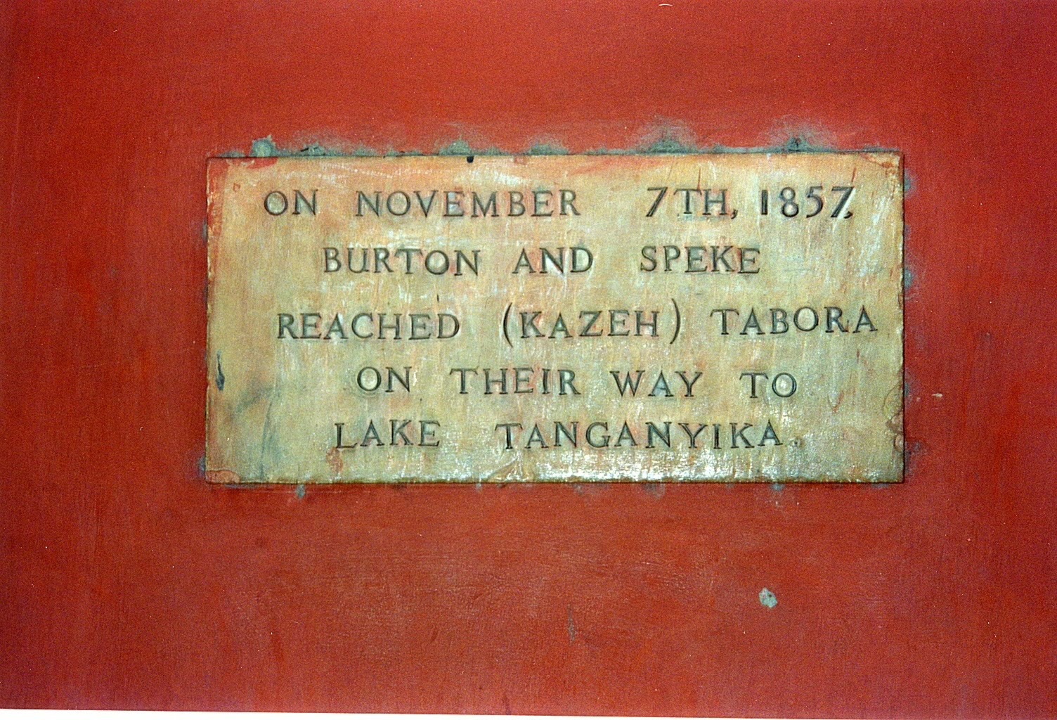
There were a number of early Explorers travelling in Africa.  The glamorous goal for some was to be the one, the first, to discover the source of the Nile.  These men knew each other and often journeyed together, though traditionally Explorers travelled alone.  What reminded us of them as we, in turn, travelled around, were plaques like the one below:
Notice the date is 1857,  sixteen years before Dillon arrived in Tabora.
And who were Burton and Speke?
 
BURTON:  1821 - 1890. 


He was an English geographer, explorer, translator, writer, soldier, cartographer, diplomat, spy, poet, fencer, linguist.  He could speak 29 languages, and he liked nothing better than to disguise himself and travel incognito, dressed like everyone around him.

He wrote books about his experiences, as well as on many other topics - on human behaviour, on fencing and on falconry.  He blasted colonial policies of the British Empire, comments which were not well received by those in power.  But he travelled westward from the Indian Ocean and was the first European to find Lake Tanganyika, guided along the way by local inhabitants.  Burton was a Fellow of the Royal Geographical Society and was also knighted.  His official title was Captain Sir Richard Burton.
And there was romance.   
Isabel Arundell's family were disapproving of their daughter's beau at first - wrong religion, away too much - the usual reasons!  But the romance persisted and she became Lady Burton.
The above-ground mausoleum of Sir Richard Francis Burton and Lady Burton, shown below, is a representation of a desert tent, its sandstone walls sculpted to resemble cloth rippling in a breeze. It would be an unusual design to find anywhere, but it is a particularly striking monument to find in a quiet English churchyard.
This tomb holds the two coffins of the Burtons.
For further interesting information go to:  The Sir Richard Francis Burton Project
 
SPEKE:  1827 - 1864


Travelling with Explorer Burton on one trip to Lake Tanganyika, John Hanning Speke temporarily went on a solo trip and became the first European to discover Lake Victoria, and to find the outlet which some have claimed is the beginning of the River Nile.

Burton was excessively jealous of his partner's discoveries and tried his best to downgrade Speke.

Speke died in his thirties while climbing a wall in Britain. He reached for his shotgun, it somehow fired and the bullet found his heart.  Burton used this untimely death to claim Speke had intentionally shot himself, committing suicide.  For many years Speke was put down and was denied acknowledgement, while Burton was praised and received a knighthood. 
A tragedy, but Speke's value is now being restored.


There is a monument to Speke in Kensington Gardens, in London


GRANT:  1827 - 1892
 

James Augustus Grant's name appears on plaques occasionally, too.  He travelled with Speke.  The combined journeys of Burton, Speke and Grant may be seen in this map:


Can you spot Speke's solo march to the great Lake Victoria, represented by a line of little blue dots

Grant suffered an ulcer in a leg early on, and he spent much of his time being nursed back to health.  He could not walk, so was carried on a stretcher.  But he was a tough Scot, having been born in the Highlands, and he made it back home.  He married in 1865, and he soon settled down at Nairn, where he died in 1892.  He was buried in the crypt of St Paul's Cathedral, in London.
All Safari travellers will recognize the gazelle named after Grant, the Grant Gazelle, one of the largest of its family:
 
All three Explorers were Officers in various armies first, and each then selected to undertake their exploring journeys.  It was exhilarating for them to travel, and then to return home, receive a grand welcome and finally move around their own homeland giving talks and describing their experiences.
Imagine being present at one of these talks - the only other source of information at that time would have been dusty encyclopaedias.  These speakers were the real thing, very thrilling.
But jealousies abounded out there in the isolated bush.
Dillon's expedition suffered from these distractions, too.  All in the book!
 
AND, FAITHFUL FOLLOWERS, TODAY I SEE THE BOOK IS LISTED AS
 
"Coming Soon"
in the following link:
 
 
Our travels together through these pages are not yet over.  Next time let's pay a visit to the Royal Geographical Society in London, where artefacts and records from Dillon's time can be found, and where Dillon signed up for his Expedition in 1872 and where I studied for many hours in 2006.
 
Thank you for reading this post.  Welcome all new readers this week - especially those
from Belgium and from Romania.


Thursday, 13 March 2014

Today

TRUCKS  AND  BOATS  TODAY
 Wherever man settles, congestion follows.


Even in a village, local vehicles gather


Along the beaches of the Indian Ocean, 
boats accumulate.


Waiting for high tide and good fishing.


Children play games amongst the stranded boats


Between the villages and the waterways, transport of goods has greatly improved.


This is a mattress truck.


An oil truck does its best


As happens world-wide, this logging truck is careening along the road, dust flying, on its way to the log-sorting yard!

(And - YES - that's a Canadian flag flying attached to our vehicle - our intrepid leader brought it in her suitcase and attached it to our vehicle)

 
 Road-building creates scars across the landscape, and the quarries, too, where gravel and sand are scraped from the surface, are left  and can be viewed from Space.

This is a quarry abandoned when local roadways were finished - only a couple of years ago - mounds already rounded by several rainy seasons of pounding rainfall.


As we approached major centres, city traffic began to pile up - and slow down.

The noise intensified as every driver honked his horn all the time.


Traffic jammed, and finally came to a full stop.

Vendors cruised these jams, trying to sell their wares.

One fellow ran by and reached inside our vehicle and tried to snatch a camera.

 Some of our group bought handicrafts which were not for sale in stores.


Making the best of it all, these stoppages developed into social events.


Traffic blockages were often due to the meeting of a narrow street and a not-so-narrow vehicle


This driver just got across the bridge, but we had to wait a while..  There was concern his load might be too heavy for the bridge . .


The speediest way to travel around is by plane.

This is a Police Plane

And these UN planes dot the small airports across the landscape.

No-one knew why they were there, when they had come, when they would leave, who was travelling on them.

But it was good to see them there, all the same.


To see Africa from a plane, watch again the movie Out Of Africa 
There is some great footage in there.

But I always prefer the countryside, so I'll leave you with the following photo - taken away from the hustle and bustle of modern-day living.
 And next time: we go back to BEFORE the time of our Dr. Dillon - to prepare for thoughts about what he encountered, as described in the book.

THANK  YOU  FOR  READING  ALONG.
And thank-you to everyone writing comments - I love them all!!

Saturday, 8 March 2014

Landmarks

LANDMARK  ROCKS

    We can be quite certain that rocks sitting on the plains on Tanzania today, were in the very same places in the 1870s.
This is exciting as it means these rocks were standing there when 
our Dr. Dillon passed by.
     The only transport for Dillon and the Expedition was with donkeys, as shown below.


And Dillon would have travelled along the main route westwards. This would have been a dust track.  These animals were not and are not shod with shoes of any type, so moving over the dust track is easier on their feet than going along the packed down roads, or the paved roads. 


We drove along the packed road shown here. 


More modern paved roads are raised up to allow water run-off during the rainy seasons.


 A cart being pulled along by two cows travels along the track beside the paved road which is built to allow rain run-off.

The road pavement would have torn away at the cows' hooves


Parts of the plains of Tanzania, between the Indian Ocean and Lake Tanganyika, are littered with landmarks on all sides along the way.

These landmarks are rocks, either now in piles or groups, or very large rocks standing out on their own.


Each rock pile looks different.  To those travelling past, they seem to cheer you on your way.

I was always interested in the rocks, on the look-out for the rocks sketched in Cameron's book "Across Africa."

Here are copies of the two main sketches:


These sketches show 2 campsites set up by members of the Expedition.

These giant rocks are what my geological adviser tells me are erratics.

They were carried to their present location by some massive force - either moved by a glacier, or by a glacial flood - where the back end of a glacier melts faster than the front end, forming a lake which bursts out through the front dam of ice at some point and sweeps all before it across the plains in a spectacular surge of power.


And then - 

I was CERTAIN I had found this rock sketched on the left.  I was CERTAIN I had touched where Dr. Dillon, his friend Lt. Cameron and their supporters had camped for a few days' respite.


Long-distance view


 There were no other erratics that we saw that even remotely resembled this shape.


Closer


Right there!


Perhaps it was THE ROCK, but when I got home and checked all the pics again, I wasn't so sure!
But - doesn't really matter if not perfectly correct!


And, how do modern-day Tanzanians travel around these plains?


They are excellent cyclists. 


And they use their bicycles for transport of personal goods


But the most frequent method of travel or transport is by walking


These women are carrying loads of wood for fuel.  

They were singing as they walked along, to encourage each other to keep going.


Here men are carrying wood along a road, with a modern truck driving up behind.

The old and the new.


Next time - modern vehicles in a vanishing world.
 Thank you for reading along.
News on book publication when I hear from publisher.